You must be logged in to get the Event Coordinator contact information.
This information session is open to all, but please note that I will be very selective in terms of who will be ultimately invited to join the trip that I plan to organize.
If you've already hiked the Chilkoot Trail, please come out to this meeting as well. I'd love to hear your tips and stories about hiking the Chilkoot Trail!
Background: In the 1890s, an estimated 100,000 prospectors descended on the Klondike region of the Yukon after the discovery of gold. A few prospectors accessed the Yukon in other ways ( for example, a few followed the Klondike Trail overland route from Edmonton), but by far the vast majority of prospectors who reached the Klondike started their journey to the Yukon in Skagway, Alaska, and then hiked over the coastal mountains to reach Lake Bennett, in Canada. Once they reached Lake Bennett, the prospectors traveled by boat for hundreds of kilometres to the gold fields near Dawson City.
Of the two routes - the Chilkoot Trail and the White Pass Trail - that the prospectors used to cross the coastal mountains, the shorter but steeper Chilkoot Trail was more popular. Photos of lines of prospectors ascending the Golden Stairs to the Chilkoot Pass are generally featured in historical descriptions of the Klondike Gold Rush. Border posts at Chilkoot Pass and White Pass were also famously established at the time by North-West Mounted Police Superintendent Sam Steele. Sam Steele's reputation for his firm but fair demeanor when dealing with unruly and independent-minded prospectors seeking to cross the pass is the subject of a famous Canadian Heritage Minute. The poet Robert W. Service also famously described the Chilkoot Trail, and the arduous journey of the people who hiked it in the 1890s, in his poem "The Trail of 'Ninety-Eight":
We landed in wind-swept Skagway. We joined the weltering mass,
Clamoring over their outfits, waiting to climb the Pass.
We tightened our girths and our pack-straps; we linked on the Human Chain,
Struggling up to the summit, where every step was a pain.....
Thus toiled we, the army of fortune, in hunger and hope and despair,
Till glacier, mountain and forest vanished, and, radiantly fair,
There at our feet lay Lake Bennett, and down to its welcome we ran:
The trail of the land was over, the trail of the water began.
Gold fever has long since subsided, but nowadays the Chilkoot Trail still is a very popular hiking trail. Signs of the large tent cities that were established in the late 1890s still remain along and near the trail. As such, the Alaska portion of the Chilkoot Trail is a U.S. National Historic Landmark, while the Canadian portion is a Canadian National Historic Site. The topography of the Chilkoot Trail is highly variable, beginning in coastal rainforest near the coast of Alaska, steeply ascending into an alpine zone, and then finishing in boreal forest.
Constraints: The Chilkoot Trail is popular, and Parks Canada imposes a quota of a maximum of 50 hikers per day crossing the Chilkoot Pass. Reservations open on January 17, 2018 for the 2018 hiking season. Hikers must specify campsite selections while making reservations.
Parks Canada and US National Parks Service staff patrol the Canadian and American portions of the trail between early June through early September. The Chilkoot is not an easy trail to hike. Some portions of the Chilkoot Trail pass through wet temperate rainforest, where hikers can be exposed to deep mud, standing water, and slick rocks and roots. Other parts of the trail are rocky, steep, and potentially covered by snow any time of the year.
The Chilkoot Pass is also considered Class 3 (Complex) avalanche terrain during the winter, and although reservations can be made to hike the trail as early as the beginning of June (and hikers can access the trail without reservations during the off-season), the avalanche risk can persist through to early- to mid-July. I would not consider myself prepared to lead a trip into terrain with this amount of avalanche risk, which is why my plan would be to do the hike later in the summer, when the trails are mostly clear and the avalanche risk has dissipated.
Potential Trip Outline:
Immediately prior to trip: Chilkoot Trail hikers must attend a mandatory 30-minute orientation session, held at the Trail Center in Skagway, Alaska. These sessions are scheduled every 2 hours beginning at 8 AM. As such, I would plan on arriving in Skagway by the day prior to beginning the hike, and would either attend the session the day before, or early (8 AM) on the first day of the hike.
The hike (assumes a 5-day, 4-night trip, but this itinerary could be shortened by compressing some of these segments together):
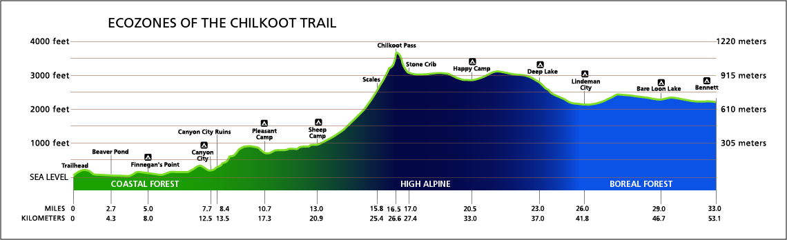
Elevation and distance profile for the Chilkoot Trail (from the US National Park Service website)
Day 1: Four campsites are located on the U.S. portion of the Chilkoot Trail (Finnegan's Point, Canyon City, Pleasant Camp and Sheep Camp). The first campsite, Finnegan's Point (km 8) is a small campsite that is mainly used by hikers who have a late start on Day 1. I would anticipate that reaching the larger Canyon City campsite (12.5 km) would be the goal for day 1. Near the camp, a short trail leads to the remnants of a steam boiler that was used to power a tramway over the Chilkoot Pass.
Distance on Day 1 (Dyea to Canyon City) - 12.5 km, 76 m net elevation gain
Day 2: After Canyon City, the trail climbs a valley wall and traverses sub-alpine forest. During the Klondike era, prospectors considered this stretch to be one of the more difficult sections. Pleasant Camp is reached at km 17.3. After Pleasant Camp, the trail weaves through forest for 3.6 km to Sheep Camp, which is the largest of the campsites on the US side. During the evening, a U.S. National Parks ranger visits Sheep Camp to present a talk about the history of the Chilkoot Trail, and to advise hikers about the conditions near the pass.
Distance on Day 2 (Canyon City to Sheep Camp) - 8.4 km, 229 m net elevation gain
Day 3: 'Crossing the Pass': The elevation at Sheep Camp is 305 m. The elevation increases considerably over the next 5.7 km before the trail crests Chilkoot Pass at km 26.6 (1067 m elevation). "The Scales" (km 25.4) - the location of a weight station during the Klondike era - are located within site of the pass. After "The Scales", a steep incline (the "Golden Stairs") must be climbed; this stretch is referred to as the Golden Stairs because of the steps that prospectors had carved into the ice and snow when they climbed this stretch during the Klondike era. A warming station and Parks Canada warden station are located at the pass, on the U.S./Canada border. After the pass, the trail descends to Stone Crib (km 27.4, 915 m elevation), which served as the terminus of an aerial tramway that was built in the late 1890s. The trail then winds its way past a series of alpine lakes, reaching Happy Camp at km 33. Happy Camp is located above the treeline, meaning that it is quite exposed to weather, and prone to being snow covered until quite late in the summer.
Distance on Day 3 (Sheep Camp to Happy Camp) - 12.1 km, 594 m net elevation gain (note: 762 m elevation gain to Chilkoot Pass over first 5.7 km; 168 m elevation loss between Chilkoot Pass and Happy Camp 6.4 km)
Day 4: After Happy Camp, the trail passes more lakes before reaching the treeline near Deep Lake. Because it is in the rain shadow of the coast mountains, the Canadian half of the Chilkoot Trail is drier than the American portion. In contrast to a lush temperate rainforest on the American portion, a drier pine forest is found on the Canadian side. A smaller campsite is found at Deep Lake (km 37). After Deep Lake, the trail enters a small canyon and the elevation gently declines toward Lake Lindeman. A large campground (Lindeman City) is found at km 41.8. Lindeman is also the base of operations for Parks Canada staff for the Canadian portion of the Chilkoot Trail. An interpretive tent is found in the Warden Camp, where hikers can pick up a trail completion certification.
Distance on Day 4 (Happy Camp to Lindeman City) - 8.8 km, 229 m net elevation loss
Day 5: The trail climbs a steep bluff after Lake Lindeman, then proceeds towards Bare Loon Lake (km 46.7). Bare Loon Lake campground (also an option for night 4) is a popular, although notoriously sometimes crowded, campground. Bennett, located on the shore of Bennett Lake, is reached at km 53.1, at the northern terminus of the Chilkoot Trail. Once a bustling tent city, Bennett is now a ghost town. Of historic interest is St Andrew's Presbyterian Church - the only gold rush era building remaining in Bennett. Several private houses are also found in Bennett, as well as a depot for the White Pass & Yukon Railroad, but there is no road access into the town.
Distance on Day 5 (Lindeman City to Bennett) - 11.3 km, 0 m net elevation gain (77 m elevation gain over 4.9 km to Bare Loon Lake, 77 m elevation loss over 6.4 km between Bare Loon Lake and Bennett)
Logistics: On the U.S. side, the trailhead for the Chilkoot is located near Dyea, Alaska 16 km (10 miles from Skagway, Alaska) along a dirt road. Travel time from Skagway to the trailhead is approximately 30 minutes (one way). Cars can be parked near the trailhead, and/or in Skagway. Private shuttle services are also available in Skagway that can take hikers to the trailhead.
On the Canadian side, the trailhead is located in Bennett, B.C.. There is no road access into Bennett. Prior to 2010, hikers could follow a side trail that diverges from the Chilkoot Trail between Bare Loon Lake and Bennett in order to reach the Klondike Highway (at Log Cabin). However, Parks Canada has closed this trail off because this route follows an active railway.
The White Pass & Yukon Route Railroad offers a Chilkoot Hikers Service. This two hour train ride takes hikers over the White Pass from Bennett back to Skagway. Departures generally occur on Tuesdays through Thursdays at 3:10 PM Alaska time, and on Saturdays at 2:10 PM Alaska time.
Costs: Reservations for campsites along the entire Chilkoot Trail (both the US and Canadian side) are managed by Parks Canada. Fees (per person) are $66.70 ($55 for backcountry camping fees plus $11.70 non- refundable reservation fee).
The cost of the train service from Bennett back to Skagway on the White Pass & Yukon Railroad was $95 per person in 2017 (USD, I assume).
More information:Parks Canada's website has an extensive description of the Chilkoot Trail, including additional descriptions of the campsites along the trail. The US National Park Service also has a description of the Chilkoot Trail.
| Recommended Items to Bring: Use our Event Checklists to make sure you have everything you need. $ for drinks and snacks |
- We encourage all members to follow our Etiquette Guidelines at all times while participating in EOC events.
- Please scroll through and read the entire online waiver when you sign up.
- Details of this event are subject to undergo a change at any point in time, with or without warning.
Suggested donation amount for this event is: $2.00/Person.
Cancellation/Partial Attendance:
Please review our Cancellation Policy carefully!